
The entire Northern Mindanao region has been placed under Tropical Cyclone Wind Signal No. 1 based on PAGASA’s latest weather advisory as of 5:00pm, December 17, 2023. Forecast track of Tropical Depression Kabayan indicate the center of TD Kabayan to be in the coastal waters of Laguindingan, Misamis Oriental by 2:00pm, December 18, 2023. Keep safe.


𝐓𝐑𝐎𝐏𝐈𝐂𝐀𝐋 𝐂𝐘𝐂𝐋𝐎𝐍𝐄 𝐁𝐔𝐋𝐋𝐄𝐓𝐈𝐍 𝐍𝐑. 𝟓
Tropical Depression #KabayanPH
Issued at 5:00 PM, 17 December 2023
Valid for broadcast until the next bulletin at 8:00 PM today.
“𝘒𝘈𝘉𝘈𝘠𝘈𝘕” 𝘊𝘖𝘕𝘛𝘐𝘕𝘜𝘌𝘚 𝘛𝘖 𝘔𝘈𝘐𝘕𝘛𝘈𝘐𝘕 𝘐𝘛𝘚 𝘚𝘛𝘙𝘌𝘕𝘎𝘛𝘏 𝘞𝘏𝘐𝘓𝘌 𝘔𝘖𝘝𝘐𝘕𝘎 𝘞𝘌𝘚𝘛𝘞𝘈𝘙𝘋 𝘌𝘈𝘚𝘛 𝘖𝘍 𝘔𝘐𝘕𝘋𝘈𝘕𝘈𝘖
𝐋𝐨𝐜𝐚𝐭𝐢𝐨𝐧 𝐨𝐟 𝐂𝐞𝐧𝐭𝐞𝐫 (𝟒:𝟎𝟎 𝐏𝐌)
The center of Tropical Depression KABAYAN was estimated based on all available data at 385 km East of Davao City or 315 km East Southeast of Hinatuan, Surigao del Sur (7.7°N, 129.1°E)
𝐈𝐧𝐭𝐞𝐧𝐬𝐢𝐭𝐲
Maximum sustained winds of 55 km/h near the center, gustiness of up to 70 km/h, and central pressure of 1002 hPa
𝐏𝐫𝐞𝐬𝐞𝐧𝐭 𝐌𝐨𝐯𝐞𝐦𝐞𝐧𝐭: Westward Slowly
𝐄𝐱𝐭𝐞𝐧𝐭 𝐨𝐟 𝐓𝐫𝐨𝐩𝐢𝐜𝐚𝐥 𝐂𝐲𝐜𝐥𝐨𝐧𝐞 𝗪𝐢𝐧𝐝𝐬
Strong winds extend outwards up to 350 km from the center
𝐓𝐑𝐎𝐏𝐈𝐂𝐀𝐋 𝐂𝐘𝐂𝐋𝐎𝐍𝐄 𝗪𝐈𝐍𝐃 𝐒𝐈𝐆𝐍𝐀𝐋𝐒 (𝐓𝐂𝗪𝐒) 𝐈𝐍 𝐄𝐅𝐅𝐄𝐂𝐓
𝘛𝘊𝘞𝘚 𝘕𝘰. 𝟷
Wind threat: Strong winds
Warning lead time: 36 hours
Range of wind speeds: 39 to 61 km/h (Beaufort 6 to 7)
Potential impacts of winds: Minimal to minor threat to life and property
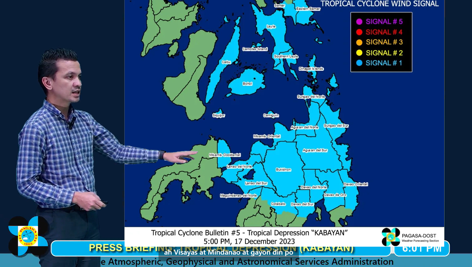
𝐕𝐢𝐬𝐚𝐲𝐚𝐬
Southern Leyte, Leyte, the southern portion of Samar (Basey, Santa Rita, Marabut, Talalora, Villareal, Pinabacdao), the southern portion of Eastern Samar (Maydolong, City of Borongan, Quinapondan, Guiuan, Lawaan, Balangiga, Llorente, Giporlos, Salcedo, Balangkayan, General Macarthur, Hernani, Mercedes), Cebu including Camotes Islands, Bantayan Islands, Bohol, and Siquijor
𝐌𝐢𝐧𝐝𝐚𝐧𝐚𝐨
Dinagat Islands, Surigao del Norte, Surigao del Sur, the northern portion of Davao Oriental (Cateel, Boston, Baganga, Manay, Caraga), Agusan del Norte, Misamis Oriental, Camiguin, Bukidnon, Agusan del Sur, Davao de Oro, Misamis Occidental, Lanao del Norte, Lanao del Sur, the northern and central portion of Davao del Norte (Santo Tomas, New Corella, Braulio E. Dujali, City of Panabo, Asuncion, City of Tagum, Talaingod, Carmen, Kapalong, San Isidro), Davao City, the northern portion of Cotabato (Arakan, Carmen, Banisilan, Alamada, President Roxas, Kabacan, Matalam, Antipas, Magpet), and the northern portion of Maguindanao (Buldon, Barira, Matanog)
𝘏𝘈𝘡𝘈𝘙𝘋𝘚 𝘈𝘍𝘍𝘌𝘊𝘛𝘐𝘕𝘎 𝘓𝘈𝘕𝘋 𝘈𝘙𝘌𝘈𝘚
𝐇𝐞𝐚𝐯𝐲 𝐑𝐚𝐢𝐧𝐟𝐚𝐥𝐥 𝐎𝐮𝐭𝐥𝐨𝐨𝐤
Forecast accumulated rainfall from today to tomorrow afternoon
• 100-200 mm: Surigao del Sur, Surigao del Norte, Dinagat Islands, and Southern Leyte
• 50-100 mm: Eastern Visayas, Davao Region, Northern Mindanao, and the rest of Caraga
Forecast accumulated rainfall from tomorrow afternoon to Tuesday afternoon
• 100-200 mm: Surigao del Sur, Surigao del Norte, Dinagat Islands, and Southern Leyte
• 50-100 mm: Eastern Visayas, Central Visayas, Northern Mindanao, and the rest of Caraga.
Forecast rainfall are generally higher in elevated or mountainous areas. Under these conditions, flooding and rain-induced landslides are likely especially in areas that are highly or very highly susceptible to these hazards as identified in hazard maps and in localities that experienced considerable amounts of rainfall for the past several days.
In addition, the Shear Line coinciding with the passage of KABAYAN may bring heavy rainfall over the eastern portion of Southern Luzon today and over the eastern portion of Luzon tomorrow. For more information, refer to Weather Advisory No. 3 issued at 11:00 AM today and the 24-Hour Public Weather Forecast and Outlook issued at 4:00 PM today.
𝘏𝘈𝘡𝘈𝘙𝘋𝘚 𝘈𝘍𝘍𝘌𝘊𝘛𝘐𝘕𝘎 𝘓𝘈𝘕𝘋 𝘈𝘙𝘌𝘈𝘚
𝐒𝐞𝐯𝐞𝐫𝐞 𝗪𝐢𝐧𝐝𝐬
The wind signals warn the public of the general wind threat over an area due to the tropical cyclone. Local winds may be slightly stronger/enhanced in coastal and upland/mountainous areas exposed to winds. Winds are less strong in areas sheltered from the prevailing wind direction.
• Minimal to minor impacts from strong winds are possible within any of the areas under Wind Signal No. 1.
Additional provinces in Visayas and Mindanao may be placed under Wind Signal No. 1 in the next bulletin.
The surge of the Northeast Monsoon will bring also gusty conditions for the next 2 days over the following areas not under any Wind Signal, especially in coastal and upland/mountainous areas exposed to winds:
• Today and tomorrow: Batanes, Babuyan Islands, Ilocos Norte, Ilocos Sur, Aurora, Bataan, Bulacan, Rizal, Quezon, Lubang Island, Marinduque, Cuyo Islands, Bicol Region, Visayas, the northern and eastern portion of mainland Cagayan, the eastern portions of Isabela and Nueva Ecija, and portions of Cordillera Administrative Region, Zambales, Pampanga, Cavite, Mindoro Provinces.
𝐇𝐀𝐙𝐀𝐑𝐃𝐒 𝐀𝐅𝐅𝐄𝐂𝐓𝐈𝐍𝐆 𝐂𝐎𝐀𝐒𝐓𝐀𝐋 𝗪𝐀𝐓𝐄𝐑𝐒
Under the influence of the Northeast Monsoon surge and KABAYAN, a Gale Warning is in effect for the coastal waters along the seaboard of Northern Luzon and the eastern seaboards of Visayas and Mindanao. Sea travel is risky for small seacraft (including all motor bancas of any type or tonnage). Mariners of these vessels are advised to remain in port or seek safe harbor. For more information, refer to Gale Warning No. 4 issued at 5:00 PM today.
𝐓𝐑𝐀𝐂𝐊 𝐀𝐍𝐃 𝐈𝐍𝐓𝐄𝐍𝐒𝐈𝐓𝐘 𝐎𝐔𝐓𝐋𝐎𝐎𝐊
• KABAYAN is forecast to track generally westward or west northwestward path across the Philippine archipelago over the next two days and is likely to maintain it strength until its initial landfall over Mindanao. However, the possibility of reaching tropical storm category pre-landfall is not ruled out.
• On the track forecast, it is likely to make landfall along the coast of Surigao del Sur or Davao Oriental tonight or tomorrow early morning, cross the rugged terrain of Mindanao, and emerge over Bohol Sea or Sulu Sea tomorrow morning or afternoon. Due to frictional effects associated with landfall, KABAYAN is forecast to weaken over land and the possibility of being downgraded into a low pressure area while over land or after emerging over the sea is not ruled out (although in such a case, re-development may still occur over the Sulu Sea).
• For the remainder of tomorrow and into early morning of Tuesday, KABAYAN will move across the Sulu Sea south of Cuyo Islands. The tropical cyclone is forecast to make another landfall over central or southern Palawan as a tropical depression by Tuesday morning, then emerge over the Philippine Sea by noon or early afternoon of the same day. Afterwards, KABAYAN may pass near or over Kalayaan Islands in the West Philippine Sea.
• It is imperative to stress that the projected track and intensity of the tropical depression remain subject to change, given its nature and strength.
Considering these developments, the public and disaster risk reduction and management offices concerned are advised to take all necessary measures to protect life and property. Persons living in areas identified to be highly or very highly susceptible to these hazards are advised to follow evacuation and other instructions from local officials. For heavy rainfall warnings, thunderstorm/rainfall advisories, and other severe weather information specific to your area, please monitor products issued by your local PAGASA Regional Services Division.
The next tropical cyclone bulletin will be issued at 8:00 PM today.
DOST-PAGASA